
The Canadian Transportation System
Highway and air infrastructure
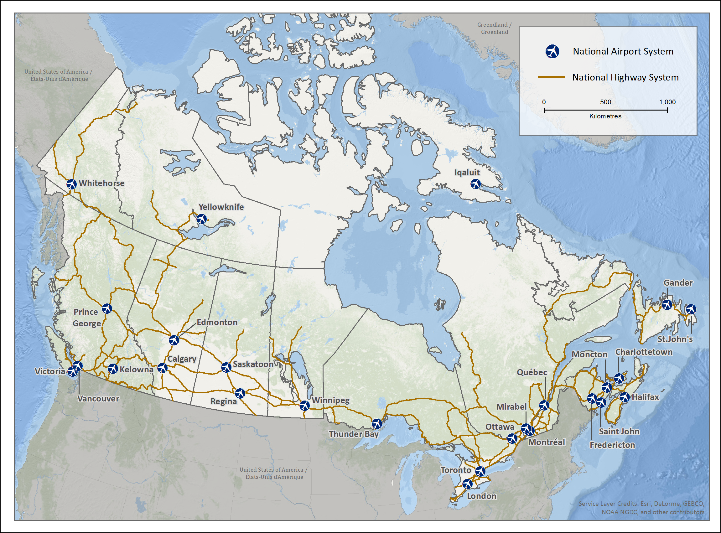
Description: Highway and air infrastructure
The map of Canada shows the 26 airports that are a part of Canada's National Airport System (NAS). Each airport is shown as a white plane in a blue square. Seven of these airports are in the Atlantic Provinces, three in Quebec, four in Ontario, five in the Prairie Provinces and four in British Columbia. The three other airports are in the capitals of each territory.
The map of Canada also shows the National Highway System (NHS) as burgundy lines that show over thirty-eight thousand kilometres of Canada's most important highways from coast to coast.
Air transportation
Canada is the third largest aerospace sector in the world. The Air Navigation Service (NAV CANADA) manages Canada's 15,000,000 km2 of airspace. NAV CANADA is a privately run, not-for-profit corporation that owns and operates Canada's civil air navigation system. It operates air traffic control towers at 41 airports and flight service stations at 55 airports. The Canadian Airport System (NAS) includes:
- 26 airports in the National Airports System (NAS)
- 71 regional and local airports serving scheduled passenger traffic
- 31 small and satellite airports without scheduled passenger services
- 13 remote airports providing the only reliable year-round transportation link to isolated communities
- 11 Arctic airports (including the three territorial capital airports counted already in the NAS)
Overall, the Canada Flight Supplement and the Canada Water Aerodrome Supplement listed 1,594 certified and registered sites in 2016, which includes:
- water bases (for float and ski planes)
- 370 heliports for helicopters
- 1,002 land airports for fixed wing aircraft
Road transportation
There are more than 1.13 million two-lane equivalent lane-kilometres of public road in Canada. About 40% of the road network is paved, while 60% is unpaved. Four provinces—Ontario, Quebec, Saskatchewan, and Alberta — account for over 75% of the total road length. In 2015, the National Highway System (NHS) included over 38,075 lane-kilometres.
In 2015, more than 23.9 million road motor vehicles were registered:
- over 92% were vehicles weighing less than 4,500 kilograms (mainly passenger automobiles, pickups, Sport Utility Vehicles (SUV) and minivans)
- about 4% were medium and heavy trucks weighing 4,500 kilograms or more
- about 3% were other vehicles such as buses, motorcycles and mopeds.
Rail and port infrastructure
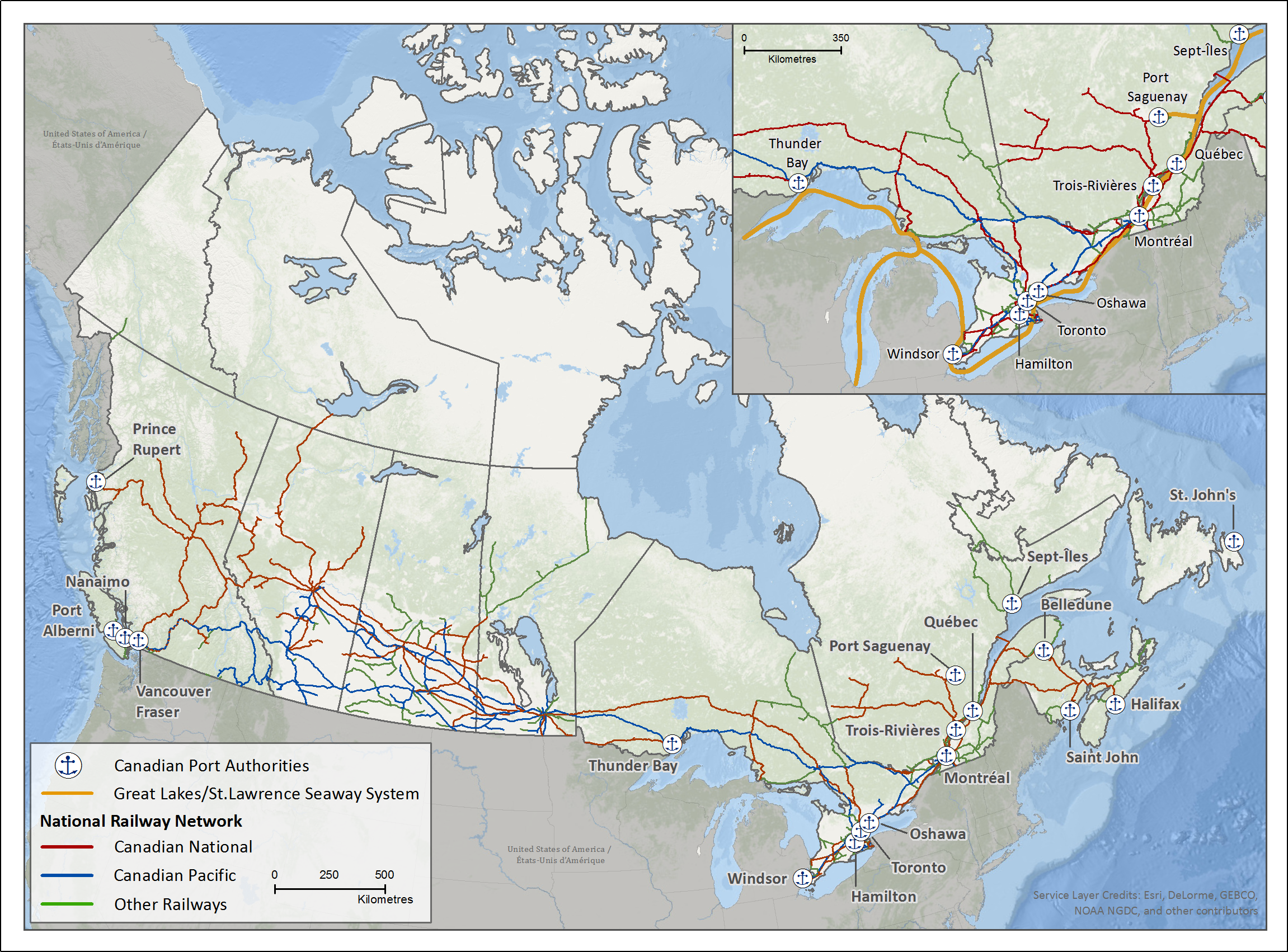
Description: Rail and port infrastructure
The map of Canada shows the approximate location of the 18 Canadian Port Authorities (CPA). Each is shown as an anchor in a blue square. The CPA ports are (in alphabetical order): Belledune, Halifax, Hamilton, Montréal, Nanaimo, Oshawa, Port Alberni, Prince Rupert, Quebec, Saguenay, Saint John, Sept-Îles, St. John's, Thunder Bay, Toronto, Trois-Rivières, Vancouver Fraser and Windsor.
The orange line in the insert at the top right of the map shows the Great Lakes/St. Lawrence Seaway System. This system provides a strategic waterway into the North American heartland. It includes ports and locks (with eight locks in the Welland Canal and seven between Montréal and Lake Ontario).
The map of Canada also shows the layout and extent of the Canadian rail system. This system currently has over 45,000 route-kilometres of track:
- The red lines show Canadian National track (49.1 per cent of the system)
- The blue lines show Canadian Pacific track (25.7 per cent)
- The green lines show other railways track (25.2 per cent)
Marine transportation
As of December 2016, Canada had:
- 559 port facilities
- 866 fishing harbours
- 129 recreational harbours
- 18 ports, including many of Canada's major ports that are independently managed by Canada Port Authorities (CPAs).
Great Lakes–St. Lawrence River
This marine system covers a large area from its western point at Thunder Bay/Duluth (U.S.) through the Great Lakes St. Lawrence Seaway System and ends at the opening of the Gulf of St. Lawrence. The System serves 15 major international ports and 50 regional ports that connect to more than 40 provincial or interstate highways and 30 railway lines.
West Coast
The Port of Vancouver and Port of Prince Rupert are the West's two main gateways for international trade. Domestic marine activities also play an important role in British Columbia's economy.
Atlantic Canada
Many marine activities also take place in Canada's four Atlantic Provinces.
The North
Canada's territories cover close to 40% of Canada's area, but are home to just over 113,600 people greatly dispersed among many small communities that are often separated from each other by hundreds of kilometres of land and water:
- Since they are so remote, seasonally operated marine transportation plays a critical role in the resupply of basic necessities sourced from southern Canada.
- Resource projects rely on marine transportation to move equipment and supplies from the south and to get their products to southern markets.
Rail transportation
The Canadian Rail System currently has 45,199 route-kilometres (km) of track, and includes:
- 19 intermodal terminals operated by either Canadian National (CN) or Canadian Pacific (CP) to run truck/rail and container intermodal services and
- 27 rail border crossings with the U.S.
On a system-wide basis, railways invest about 20% of their revenue into infrastructure, which averaged about $1.8 billion a year over the past five years.
The rail transportation sector specializes in moving heavy, bulk commodities and containerized traffic over long distances. Its passenger function includes providing commuter, intercity and tourist rail services.
Over 60 railways operate in Canada. About half of them operated under federal jurisdiction in 2016, including three Canadian Class I railways (CN, CP and VIA Rail) and several U.S. railways.
- Date modified: